Maps for family historians
Ever considered using maps to get to know your ancestors?

Maps in our collections document the European settlement of land, which also means they document the dispossession of its traditional owners. Early maps may reveal tracks later used by Europeans as roads; they document the establishment of Aboriginal Reserves, and later maps may record archaeological evidence.
Maps and plans can shed new light on how your forebears lived and worked, and on events that shaped their lives. In some cases, old maps may be the only historical evidence available to you for certain types of information. Researching the land on which your ancestors lived can also help you understand their sense of home and belonging.
A map may provide specific information about your ancestor. For example, a glance across a parish map may reveal that your canny great grandmother owned five properties, not just one. You may be able to use the information on the parish map to track down her title deeds. Old maps may outline buildings on her properties that no longer exist.
A map may also provide contextual information that gives clues to your ancestors’ lives. Was there a particular industry in the area? Did they live near a river that was prone to flooding? Were there slums or parklands nearby? What sort of infrastructure existed?
And think about what wasn’t available, such as hospitals or railways — absences that would have affected life events and family decisions.
We hold many different types of maps that family historians find very useful. For example:
- parish, town and county maps
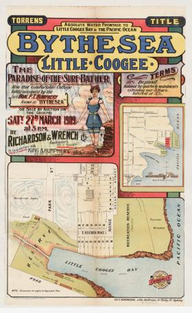
- property surveys and subdivision plans drawn up by real estate agents selling parcels of land
- pastoral maps of farms across NSW
- maps that record infrastructure such as buildings, transport and electricity lines.
- orthophoto maps that overlay the map with an aerial photo
- maps that document an event, such as battlefield maps, can help us understand the experiences of our soldier forebears.
Let’s look at two examples:
Parish, town and county maps were created to act as an index to documents about Crown land and documents about land subsequently transferred to private ownership such as title deed numbers. They also record government activities that may have impacted families such as the resumption of their land. They link localities to Government Gazette notices available on Trove.
Compare successive editions of parish maps to understand how the area developed. The Historical Land Records Viewer (HLRV) database provides free access to the old working copies of these maps and to your ancestors’ crown grants, title deeds and other documents. We’ve put together four webinars and step-by-step guides about the HLRV to help you get started.
![Parish of Farnham, County of St Vincent [cartographic material] : Clyde Shire, Land Districts of Nowra & Milton, Eastern Division N.S.W. / compiled, drawn and printed at the Department of Lands, Sydney N.S.W. Parish of Farnham, County of St Vincent [cartographic material] : Clyde Shire, Land Districts of Nowra & Milton, Eastern Division N.S.W. / compiled, drawn and printed at the Department of Lands, Sydney N.S.W.](/sites/default/files/styles/max_width_280/public/slnsw_fl9151251.jpg?itok=7SpzSyuk)
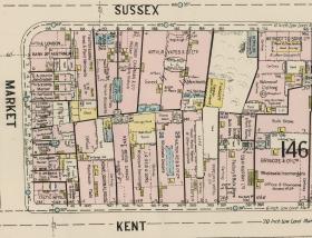
Insurance maps: Did you find your ancestor in the Sands Directory listed as living in or running a business in the city? We have several digitised series of insurance maps covering the Sydney CBD from 1880s to the 1940s that record names of occupants and businesses, information about the building, carriage yards, nearby facilities and other details. One example is the Fire and Accident Underwriters Association of NSW maps.

Try your hand: In our new catalogue, type in the name of a town or suburb, click on Formats and select Maps, tick Available online then browse the high-resolution digitised maps at home.
If you are looking for our famous collection of 40,000 subdivision plans, type in the name of the suburb or town and the keywords subdivision plans. All the Sydney suburbs are fully digitised.
Keep in mind that many related resources will be useful when using maps such as gazetteers, directories, electoral rolls, family papers, photographs, local histories, websites and databases. If you are unsure where to start, try our Maps Research Guide and always feel free to ask a librarian.
Happy Mapping!
Wendy Holz, Information & Access.