One of the Library’s most valued possessions, the Tasman Map, depicts the results of explorer Abel Tasman’s two voyages between 1642 and 1644.
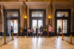
Tasman Map in the Mitchell Vestibule
A magnificent marble version of the original Tasman map can be found on the floor of the State Library’s historic Mitchell building vestibule. Measuring a massive 5.71 metres x 4.29 metres, this unique piece of public art was created from 1939–41 by the Melocco Brothers, Sydney’s leading marble and mosaic craftspeople at the time.
Taking inspiration from the floor map installed in Amsterdam’s Town Hall in the mid 17th century, the brothers spent thousands of hours painstakingly creating the stunning mosaic based on the original Tasman map held in the Library’s collection. The mosaic is made up of 45 slabs of 22 mm thick marble, with coloured marble granules and inlays of brass used to outline the ships and decorative features.
The brothers selected Wombeyan marble for the base to reflect the parchment colour of the original Tasman map and for its hardwearing nature. European marble was unavailable due to the impact of the war in Europe.
The map is bordered by a green and cream terrazzo floor, decorated with traditional 17th century mapmakers’ motifs, including cherubs and navigational instruments. Appearing among the waves are brass filigree ships and several sea monsters.
One of the most extraordinary pieces of public art in Sydney!
The Tasman floor map was first unveiled to the public with the opening of the Mitchell building’s grand extensions in 1942, which also included the sandstone portico and the main reading room (now known at the Mitchell Library Reading Room).
What to look out for
The dotted lines on the map represent the routes of Tasman’s two voyages. The Heemskerck and the Zeehaen, the two ships used in Tasman’s first voyage (1642–43), can be seen at the base of the map (in the Great Australian Bight).
The coat of arms of the city of Amsterdam, with the date 1644, appears just below the Tropic of Capricorn.
Below the map, is the coat of arms of the House of Nassau, the ruling Dutch family during Tasman’s time; the motto translates to ‘small things increased by concord’.
Tasman’s first voyage also recorded the first European encounters with New Zealand, Fiji and Tonga. You can see these islands to the right of the map.