A day in the Mitchell Library is always filled with the promise of discovery.
But, of course, it’s mostly the slow but satisfying slog of research. Today is no different. I’m looking through microfilm copies of the papers of the Reverend John McGarvie, Presbyterian minister at Pitt Town and Ebenezer on the Hawkesbury River in the late 1820s, hoping as ever for glimpses of this river Country and its people.
So far it’s slim pickings. Reverend McGarvie spent a lot of time writing long, elaborate poems and wordy diatribes for the Sydney Gazette, but very little time describing what life was like on the river.
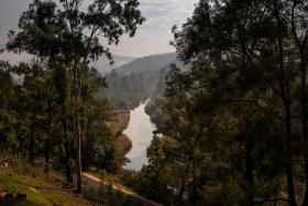
I keep scrolling, and suddenly a list appears on the screen. It’s headed ‘Native names of places on the Hawkesbury’. And there follow five pages of Aboriginal placenames along Dyarubbin (the Hawkesbury River), over 170 of them, written neatly in ink or pencil.
I’m stunned. I sit there staring at the screen, hardly believing my eyes. After years of research, my own and others, I had thought that most of the Aboriginal names of the Hawkesbury were lost forever, destroyed in the aftermath of invasion and dispossession. Yet, suddenly, this cache of riches.
Looking more closely, it’s clear that McGarvie took a lot of care with this list. The names appear to be in geographic order, and he included locational clues, like settlers’ names, creeks and lagoons.
An extraordinary idea dawned on me: what if we could restore these names to their places on the river? And then: what if these beautiful, rolling words came back into common usage?
The scores of names on these pages contrast so strikingly with the modern landscapes of the Hawkesbury and Western Sydney. Once every place had an Aboriginal name. Now there are so few reminders of Aboriginal history and presence.
Yet Western Sydney is home to one of the biggest concentrations of Aboriginal people in Australia. With some important exceptions, Aboriginal people rarely see themselves represented in key heritage sites, or in the everyday reminders and triggers of public memory. Could this list be the catalyst for change, for shifting the shape of our landscapes towards recognition of Aboriginal history?
I contacted Darug knowledge-holders, artists and educators Leanne Watson, Erin Wilkins, Jasmine Seymour and Rhiannon Wright, asking if they would be interested in working on a project based on McGarvie’s list. The response was instant: in fact I was bowled over by their enthusiasm!
We designed the ‘Real Secret River Dyarubbin’ project together, and were thrilled when it won the State Library’s Coral Thomas Fellowship for 2018–19. This generous fellowship brought the project to life: not only because the funding enabled us to carry out the research and fieldwork, but because the Library and its staff have been so welcoming and supportive.
Looking back, it seems uncanny that McGarvie’s list reappeared when it did – after all, we are in the midst of an extraordinary period of Aboriginal cultural renewal and language revitalisation.
The project’s Darug researchers are committed to these quests. They want to research and record Aboriginal environmental and cultural knowledge and raise awareness of Aboriginal presence and history in the wider community. And because the Aboriginal history of Dyarubbin is continuous, the project includes an oral history component, recording twentieth century Aboriginal voices and stories of the river.
So it was obvious that McGarvie’s words could be more than a list of names: it could be the key to a bigger story about the real secret river, Dyarubbin, and the Aboriginal history that was lost, submerged below what Tom Griffiths called ‘the white noise of history making’.
But to do this, we need to put the words in their wider context: we need to see the river whole. Besides reconnecting the list to living Aboriginal knowledge, the project explores the history, languages, ecology, geography and archaeological evidence of the Hawkesbury River.
Our multidisciplinary team includes archaeologist and historian Paul Irish, linguist and anthropologist Jim Wafer, and photographer Joy Lai. Many local experts have also given generous support for the project, including Hawkesbury historians Michelle Nichols and Jan Barkley-Jack, curator Rebecca Turnbull and geologist, historian and bushwalker extraordinaire Gil Jones.
The Library’s collections hold so many precious clues to recreating the world of Dyarubbin in the early colonial period. Early maps showing the old river farms help us work out where the Aboriginal names belong. They also record long-lost landscapes of swamps, lagoons and creeks – important places for Aboriginal people that have since disappeared.
The letters and journals of Hawkesbury settlers contain hints about the ways Aboriginal people and settlers lived in this country over the nineteenth century. Local Aboriginal people befriended some of the settlers, like the Hall family at Lilburndale, and cultivated this relationship over generations. The Hall family papers hold some powerful and poignant traces: store receipts for goods Aboriginal people were purchasing from them, for example, and lists of the work they did at Lilburndale.
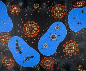
What about the words on McGarvie’s list? What can they tell us? Jim Wafer and Darug team members are working on a glossary in six local and adjacent Aboriginal languages. Some of these words refer to specific places, environments and objects: caves and types of trees and plants, or tools and weapons.
Perhaps most evocative are two different words meaning ‘rainbow’: Dorumbolooa and Gunanday. Both are located in places with dramatic cliffs and sharp river bends. These words are probably linked with Gurangatty, the great Eel Being, who is associated with rainbows, and who created the river and its valley in the Dreaming, leaving awesome chasms and sinuous bends in his wake.
Such words remind us of something obvious, and profound: if Aboriginal people are to be at the centre of this story, we need to look beyond European history and landscapes, beyond European knowledge and ways of thinking.
Dyarubbin and its tributary Gunanday (the Macdonald River) are part of a much larger, immensely rich archaeological zone, reaching from the Blue Mountains and the Wollemi in the west and up to the Hunter Valley and Lake Macquarie in the north. Many of the major recorded archaeological sites have sacred, spiritual and ceremonial meanings, especially those located on high places.
Closer to the river, Paul Irish’s archaeological mapping has revealed how much of the Aboriginal cultural landscape survives today within the ‘settler’ landscape. From Richmond in the south, to higher Macdonald in the north, the river corridors are lined with more than 200 archaeological sites, including engravings, grinding grooves, stone arrangements and rock shelters, some with scores or hundreds of images in ochre and charcoal.
This search for Dyarubbin, the real secret river, is framed and guided by an Aboriginal sense of Country: the belief that people, animals, Law and Country are inseparable, that the land is animate and inspirited, that it is a historical actor.
Grace Karskens is Professor of History in the School of Humanities and Languages at the University of New South Wales. Her latest book, The Colony: A History of Early Sydney, won the 2010 Prime Minister’s Literary Award for non-fiction and the US Urban History Association’s prize for Best Book 2010. She is the Library’s 2018–19 Coral Thomas Fellow.