Factors that shape places: Shoalhaven river
Key inquiry question #1
How do people and environments influence one another?
Content
Environments shape places
Students:
- investigate how the natural environment influences people and places, for example: (ACHGK028)
- discussion of how climate influences the distribution of where people live
- comparison of how landforms influence where and how people live in Australia and another country
Background Notes for Teachers
Scope
Using the settlement around the lower Shoalhaven River, this learning sequence looks at how the natural environment, particularly landform and climate, influence where and how people live. Throughout history people have made decisions about where to live based on the natural environment and how it supports human settlement. Significant factors include how the landforms and climate support the production of food and fibres, resulting in settlements in Australia in coastal areas compared with inland.
Inquiry process
Students will investigate the topic using the Geographical Inquiry Process which is guided by inquiry questions behind a definition of geography put forward by Charles F. Gritzner. It uses the inquiry questions of What is? Where is? Why there? and Why care?
- Where is the Shoalhaven River area?
- What are the natural and human features of the Shoalhaven River area?
- Why is there settlement in the Shoalhaven River area? How has the natural environment influenced the settlement?
- Why care? How will the natural environment influence settlement in the Shoalhaven River area in the future?
- Defining Geography: What is Where, Why There, and Why Care? by Charles F. Gritzner, Journal of Geography 101, No. 1 (January/February 2002), pp. 38-40.
Virtual Fieldwork
This lesson sequence explores the geographical concepts of environment, interconnection and change through a rich series of aerial photos by Daryl Jones in the State Library of NSW collection. This resource provides the opportunity for detailed analysis of the geographical features of the area. The historical perspective is provided through a collection of photographs of the original settlement in the area: the Coolangatta Estate of David Berry, when the area was originally established as a dairy farming area.
Shoalhaven River area
The Shoalhaven River area, like many settlement areas along the east coast of NSW, was settled historically due to its floodplains which were rich in alluvial soils. These made themidealifor agriculture. The Illawarra Escarpment to the west influences the amount of rain experienced along the coast and provides regular rainfall able to support crops and dairy farming. The temperate climate with warm summers and cool winters also allows for agricultural industries to thrive and provide a comfortable climate for people to live. These factors, along with the lifestyle afforded by the rich natural environment such as the river and beaches, have ensured the population of the area continues to grow.
As people continue to come to the Shoalhaven River area, as tourists and as new residents, extra pressures are put on the natural environment. One of the main factors with the increasing population is urban development and where to expand the settlement. As the Illawarra Escarpment to the west and the ocean to the east provide geographical barriers to housing development, most housing is being built on the river flats, particularly in high areas of farming land where the land has already been cleared of vegetation and is not susceptible to the flooding.
Link to Stage 3 History The Australian Colonies
As an historical inquiry, students could investigate aspects of daily life of the colonial inhabitants of the Shoalhaven River area in the 1800s and the impact of settlement on local Aboriginal people and the environment. They could also investigate the role of Alexander Berry and his brother David Berry as significant individuals in shaping the colony.
Student Activities
Shoalhaven River area
Students examine a source and discuss natural and human features. They formulate inquiry questions.
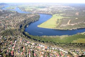
Where is the Shoalhaven River area?
Students locate the Shoalhaven River area using an atlas or Google Maps. They identify where it is in relation to Sydney, Canberra and their local area.
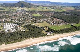
What are the natural and human features of the Shoalhaven River area?
Students examine photos of the Shoalhaven River. They discuss the questions to identify the natural and human features of the area.
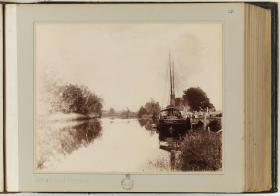
Colonial settlement
Students view source photos. They brainstorm interconnections between the natural environment of the area and why it was settled.
Why is there continued settlement in the Shoalhaven River area? How has the natural environment influenced the settlement?
Students consider questions on human development and the impact on the local environment and complete a table.
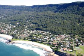
Why care? How will the natural environment influence people and places in the Shoalhaven River area in the future?
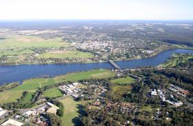
Students study a photograph of the Shoalhaven river and select a suitable site for a new housing development.
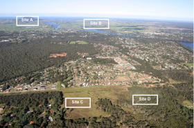
Why care? How will the natural environment influence people and places in the Shoalhaven River area in the future?
Students look at a photo of Shoalhaven River and select a suitable site for a new housing development. They justify their choice demonstrating interconnections between settlement and landform.
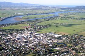
NSW Syllabus for the Australian Curriculum Geography K–6
A student:
- GE3-1 describes the diverse features and characteristics of places and environments
- GE3-2 explains interactions and connections between people, places and environments
- GE3-4 acquires, processes and communicates geographical information using geographical tools for inquiry
Acquiring geographical information
- develop geographical questions to investigate and plan an inquiry (ACHGS033, ACHGS040)
- collect and record relevant geographical data and information, using ethical protocols, from primary data and secondary information sources, for example, by observing, by interviewing, conducting surveys, or using maps, visual representations, statistical sources and reports, the media or the internet (ACHGS034, ACHGS041)
Processing geographical information
- evaluate sources for their usefulness (ACHGS035, ACHGS042)
- represent data in different forms, for example plans, graphs, tables, sketches and diagrams (ACHGS035, ACHGS042)
- represent different types of geographical information by constructing maps that conform to cartographic conventions using spatial technologies as appropriate (ACHGS036, ACHGS043)
- interpret geographical data and information, using digital and spatial technologies as appropriate, and identify spatial distributions, patterns and trends, and infer relationships to draw conclusions (ACHGS037, ACHGS044)
Communicating geographical information
- present findings and ideas in a range of communication forms as appropriate (ACHGS038, ACHGS045)
- reflect on their learning to propose individual and collective action in response to a contemporary geographical challenge and describe the expected effects of their proposal on different groups of people (ACHGS039, ACHGS046)
- Place: the significance of places and what they are like (ie. characteristics of places on a global level).
- Space: the significance of location and spatial distribution, and ways people organise and manage spaces that we live in (ie. global patterns of spatial distribution; how people organise and manage spaces in their local environment).
- Environment: the significance of the environment in human life, and the important interrelationships between humans and the environment (ie. how the environment influences people and places; how people influence the environment; the effect of natural disasters on the environment).
- Interconnection: no object of geographical study can be viewed in isolation (ie. how environments influence where people live; ways people influence the characteristics of their environments; diversity of cultures and peoples around the world).
- Scale: the way that geographical phenomena and problems can be examined at different spatial levels (ie. environmental and human characteristics of places on local, regional and global scales; the effect of global events on people and places locally, regionally and globally).
- Sustainability: the capacity of the environment to continue to support our lives and the lives of other living creatures into the future(ie. extent of environmental change; environmental management practices; sustainability initiatives).
- Change: explaining geographical phenomena by investigating how they have developed over time (ie. changes to environmental and human characteristics of places).
Learning Across the Curriculum
- Sustainability
- Information and communication technology capability
- Critical and creative thinking
- Literacy
- Numeracy
- Personal and social capability
- Civics and citizenship
- Difference and diversity
- Work and enterprise
Resources
Books
Pictorial History of the Shoalhaven District by Roger Coombs
Websites
Bureau of Meteorology Climate Zone Maps
Bureau of Meteorology – Nowra climate statistics
Coolangatta Estate, State Library of NSW Discover Collections
Shoalhaven Council YouTube channel
Shoalhaven Council – climate, soils, flora and fauna information